The Geology of the Sierra Nevada
The Sierra Nevada mountains “proper” exist entirely within the state of California, stretching from Southern California’s “Grapevine” pass to just south of Lassen Peak near Susanville, where they transition into the volcanic Cascade Range . However, the Carson Range that forms the western boundaries of the Truckee Meadows and Carson Valley is considered to be a branch of the Sierra. In the last article we discussed the north-south parallel faults of the Basin and Range . The westernmost boundary of that region is a fault running under the western edge of Lake Tahoe , above which rises the main “block” of the Sierra. To the east, above the far shore of the lake, rises the Carson Range.

The term “block” is appropriate, as the 400-mile length of the Sierra is a huge mass of granite and similar rocks, known as the Sierra Batholith . In geology, a batholith is the largest type of pluton . Named for Pluto, the Roman god of the underworld, plutons are bodies of igneous rock which cooled far underground after molten magma was injected into surrounding older rock. In contrast to volcanic eruptions at the surface, plutons often form several miles under the surface and may take millions of years to solidify. This gives time for larger crystals to form and is why the separate minerals like quartz, feldspar, and biotite mica can be easily distinguished in granite, a plutonic rock. This contrasts to the fine-grained textures of basalt or rhyolite , which are volcanic and solidify in hours, days, or years. The brown and yellow rhyolite outcrops seen in Virginia Range resulted from fairly recent volcanic activity and are therefore quite different from the gray cliffs and rounded boulders of granite that are so plentiful around Lake Tahoe.
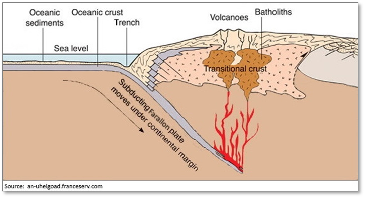
In the last article we also discussed the subduction of the Farallon oceanic plate under the North American plate, which took place continuously from about 165 million to 30 million years ago. This was the source of the huge volume of magma that fed the Sierra batholith. As the subducting plate reached great depths, much of the rock melted, either from the high ambient temperatures or possibly from the trapped heat of the decay of trace radioactive elements. The resulting magma was less dense than the crust above it and gradually rose upward. In some places it reached the surface and erupted in volcanos or lava flows but most of it intruded into fissures and faults in the surrounding country rock and became trapped miles below the surface.
Over the millennia, many individual plutons were intruded, resulting in what appears today as a single, massive block of igneous granitic rock, several miles in thickness, covering the entire length of the present-day Sierra. The varying mineral composition of the rock in different sections of the range, as well as advanced radioactive dating, confirms that there were actually hundreds of plutonic intrusions, with majority occurring between 105 and 85 million years ago.
As the batholith was forming, other tectonic forces began to cause the entire region to steadily rise by thousands of feet. Whenever the topography presents higher terrain, erosion will begin to attack rising landmass, wearing away the overlying rock. In this way, the newly formed granitic rock eventually became the new land surface in many places, interspersed with remnants of the metamorphic and volcanic rock that had covered it. Paleobiologic studies have indicated that the climate east of these ancestral Sierras was nowhere near as dry as it is today, so it is likely that at that earlier stage the mountains relatively modest in height. Another phase was yet to come, though.
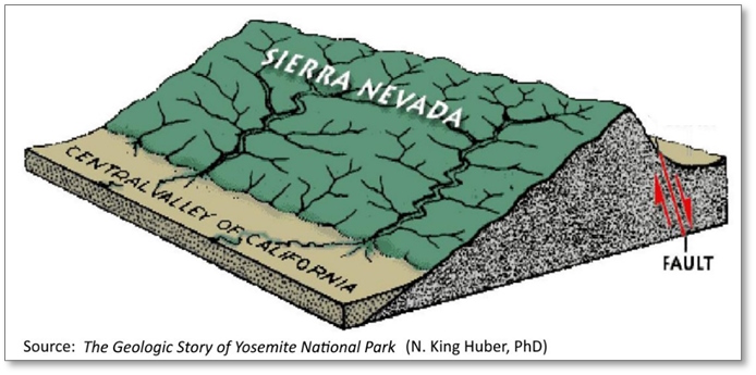
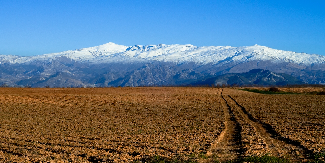
You may recall that the faulting of the Basin and Range began as the Farallon plate had completely subducted under the North American continent and, at our latitude, was replaced by larger Pacific plate with its northwestward motion (the new plate boundary being the San Andreas fault). Tectonic forces over the entire region shifted, such that volcanic and plutonic activity were now limited to much more localized areas. The accumulation of the massive Sierra Batholith was effectively over but under the new tectonic conditions it was replaced by a large-scale tilting of the entire mass, now cooled into solid granite, toward the west. The tilting began about 10 million years ago. The eastern edge rose many thousands of feet along a block fault, while the western portion dipped well below sea level. Since this process took millions of years, with erosion continuing throughout, huge volumes of sediment flowed into the depression on the west of the block, and the actual land surface likely never dipped below sea level. The resulting Great Central Valley of California is one of the most prominent features on any topographic map of the United States, renowned as a prolific agricultural region. As indicated by the very simplified diagram at right, this tilting has led to the western slope of the Sierra being rather gradual, while along much of the eastern boundary the block faults result in grades ranging from steep to precipitous. Were it not for the erosion by rivers like the Truckee, Carson, and Walker, it would have been nearly impossible to cross this topography with highways and railroads.
Earlier we mentioned that the Carson Range is actually a branch of the Sierra. That is because much of its core is made up of the same granitic rocks of the great batholith, but the two ranges are separated by a major fault that runs under the western part of Lake Tahoe and continues northward up the Truckee Valley. The lake owes its existence in part to the downward displacement of the crust on the east side of that fault. The lake’s full history is more complex and intriguing, though, and in next month’s article we will cover it in more detail.
The Carson Range also has a set of faults running along its eastern side, accounting for the steep slopes that we see above Reno and Carson City. The longest of those north-south faults is the Genoa Fault , which bounds much of the Carson Valley. If you have visited lovely Genoa, you may have noticed how steeply the mountains rise behind the town and its environs.
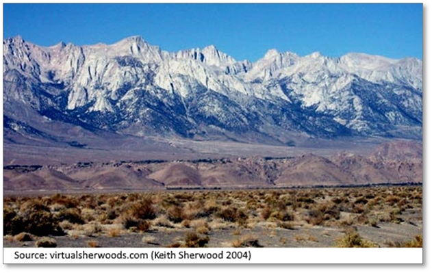
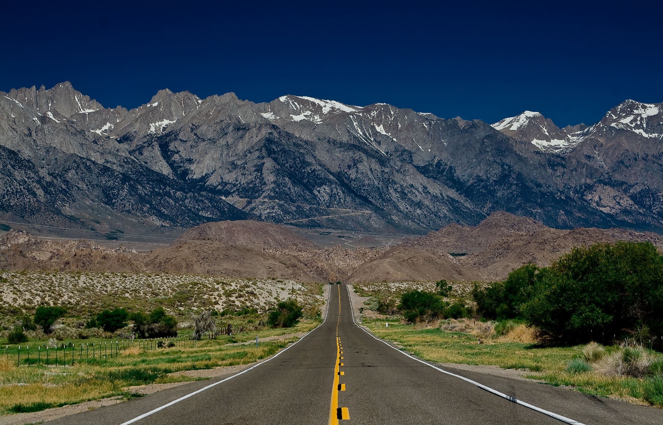
The most dramatic example of the eastern faulting of the Sierra can be seen from the Owens Valley , south of Bishop, CA. As seen in this familiar view, Mount Whitney towers nearly two vertical miles above the valley floor. At 14,505 feet above sea level, it is the highest point in the lower 48 states. Remarkably, the lowest point on the continent, in Death Valley , is only 76 miles to the south as the crow flies. This contrast is a testament to the extreme vertical fault displacements of this region, which is among the most tectonically active on the continent. The Sierra Nevada represent a living geologic event, and the peaks are still rising, particularly in the southern section. However, at an average rate of only centimeters per year, none of us will see them change significantly during our lifetimes. Such is the nature of geologic time.